If you've ever purchased real estate you may remember the deed: a legal document describing the property and declaring that the grantor, the old owner of the property, is giving it to the new owner, the grantee. A copy of the deed is usually filed with the county. This leaves a chain of deeds on file going all the way back to whatever was the original grant for the property. In the original thirteen colonies of the United States this chain goes all the way back to the original grants from the English monarch.
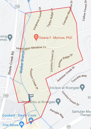
Tracey and I recently purchased a home in Mecklenburg County, North Carolina whose register of deeds maintains a searchable database of deeds filed since 1990. But there are still more deeds: the county has records going back to 1763. Incredibly, the county has scanned in all of the old deeds as well and made both databases available for free! The old deeds don't have a text search, which is unfortunate but not surprising - deeds before 1920 or so are hand written in cursive. So my mission is now clear - can I trace the title of this land all the way back to the original grants from the Lords Proprietors of Carolina?
The county organizes its deeds into books, and the deed is indexed on its page in the book. These are written out like 36356-796, where the first number is the book number and the second is the page number. Yes, there are a lot of books - they've been counting up since 1763! That deed is the start of my search as it's the deed that transferred ownership to Tracey and myself.
Deeds are pretty formulaic. They are practical instruments, meant to cleanly transfer ownership of property to the grantee. In the original thirteen colonies of the United States they often use the traditional English legal practice of metes and bounds to describe the property as if you had walked around its boundary. The most recent deeds simply reference a specific lot on an official map, also filed with the county, instead of a metes and bounds description of the property, but once we get past the immediate subdivision history of the land we'll see metes and bounds used exclusively. The metes and bounds also put the boundary line in context with the property around it - for example, when a boundary runs along a public road or highway the road will be mentioned by name. This helps with locating the property on a modern map as many of our Mecklenburg County roads have not changed names or locations in over a hundred years. However, there is still some sleuthing required when names change, or when the deed only references nearby properties by owner's name at the time of sale, such as in 3032-203:
BEGINNING at an old iron, which iron is also the common northeast corner of Mrs. R. C. Mitchell and the southeast corner of the property of A. A. Porter and J. F. Neely estate, thence with the line of A. A. Porter and J. F. Neely estate North 31-59 West 376.62 feet to an old iron; thence with the line of Duke Power Company North 22-49 East 868.34 feet to an old iron located on the line of the property of Gambrell Investment Company (formerly Marshall Reid); thence with said line of Gambrell Investment Company South 20-47 East 1,834.59 feet to an iron located on the line of Mrs. L. E. Carothers, and which iron is also located South 66-17 West 356.06 feet from an old iron; thence with the line of Mrs. L. E. Carothers South 66-17 West 627 feet to an iron; thence continuing with the line of Mrs. L. E. Carothers, the line of the 1.11-acre tract conveyed by Mrs. Helen C. Carothers (Mrs. L. E. Carothers) to Gambrell Investment Company, and the line of Mrs. R. C. Mitchell North 14-24 West for a total of 874.03 feet to the point or place of BEGINNING, containing 20.33 acres as shown on a survey prepared by E. L. Faires, North Carolina Registered Surveyor, dated September, 1968. BEING the same property conveyed to Robert O. Brown and Wife, Doris H. Brown, by deed of Nancy Porter Kirby (Widow), and Clara Sledge Woods (Widow), dated __ ___, 1967, and recorded in Book 2881, at Page 442, of the Mecklenburg Public Registry.
I know that the deed is in Steele Creek township in Mecklenburg County as it is written elsewhere on the deed. The names are also familiar - the Carothers and Neelys come up many times in Steele Creek as I've done the title research. But where is this land actually located? There's no mention of county roads, postal addresses (although deeds never mention postal addresses) or natural features like creek crossings or confluences. There is no reference to any map (although sometimes one does get filed with the county) and the survey mentioned at the end is not filed with the county. At least it mentions the prior deed and I can look up that one in hopes it has more detail. But if that can't be found you have to find the neighboring properties mentioned by owner and hope you can triangulate the location from their context.
The "irons" in the description are metal stakes left in the ground by surveyors to designate the corners of the property. Yes, this comes with all the issues of accidentally or intentionally moved or misplaced markers. As you go back in time you start seeing trees, tree stumps, or the course of creeks and rivers in these descriptions making it more and more challenging to accurately draw a map of the boundaries of the property. The property may be formally specified and records kept for hundreds of years but the passing of time makes it a challenge to recover the actual property boundaries.
In a fascinating quirk of legal history in the US the complete history of the title has to be computed and double-checked to make sure that the land can be successfully sold. Should there be any problems in the past with the ownership or sale of the land you risk having older owners, their heirs, or an entire tribe of Indians sue to regain their rightful ownership over the land. This research is done by a title insurance company before they sell you a title insurance policy which pays out should you be subject to one of these lawsuits and lose ownership of your land.
The title search
Starting with the latest deed at 36356-796 the most recent history of the land is easy to trace. Each deed mentions the previous deed by book and page number making it easy to jump to the previous deed. In the year 2004 we reach deed 17821-200 where D. R. Horton, the homebuilder, sells the newly constructed home to its initial owners. A few months before that is deed 17203-933 where Provident Development Group sells the house to D. R. Horton. I am not sure what Provident Development Group is or does but I suspect they are closely related to D. R. Horton and heavily involved in the initial construction of the Huntington Forest subdivision.
In April of 2002 the Provident Development Group acquires the land from the Steele Creek (1997) Limited Partnership in deed 13509-753. This is the first time Sarah Belk Gambrell comes up in the title history. Sarah is a partner in the the partnership and mentioned by name in the deed. We'll also find that she's a major land owner in Steele Creek. But what is her story?
If you're from Charlotte the name Belk will jump out at you. It's the same Belk as the chain of department stores (think Macy's, but southern) and the John Belk Freeway in Uptown. The department store was founded by William Henry Belk in 1888 and his son John Belk was a former mayor of Charlotte. Sarah Belk was William's daughter and passed away in 2020 at the age of 102. Sarah worked in the family business, served as an officer in the corporation, held board seats and was a major shareholder. Belk was bought out for $3 billion dollars in 2015 and Sarah had a lifetime of salary, dividends and sales from the business. Her obituary mentions the extensive philanthropic support she gave to minority interests in Charlotte. But with that money she was also heavily invested in Charlotte itself as a substantial land owner, speculating on the growth and future development of Steele Creek.
The 13509-753 deed was Sarah's sale of part of her holdings in Steele Creek to create the Huntington Forest subdivision and some other nearby properties. However, at this point the deed trail runs cold. This deed does not mention the book and page of any prior deeds like we've seen so far. Luckily, this transaction is in the post-1990 online database which allows us to search on grantor/grantee name and try and figure out what happened here. I am not sure why this deed didn't mention the previous deed but there are a couple of clues. First, there is a lawsuit between the Steele Creek Limited Partnership and the city of Charlotte to acquire land for a sewer pipe. This lawsuit ends in default judgment a year later in favor of Charlotte, awarding them title to a narrow strip of land for the sewer. There's also some deeds giving the NC Department of Transportation extra room to widen the nearby NC 160 state highway and improve the NC 160 and NC 49 intersection. The existence of the lawsuit sounds dramatic - did the city have to FIGHT to get the land from Sarah? - but my understanding is that it is a lot more mundane than it sounds. The lawsuit is simply the legal process required for the city to acquire title or an easement for this utility work. Because it is a lawsuit, run by the courts, following their due process, it gives the land owner a fair chance to defend their ownership of the land. And because the trial expired in default judgment I believe both parties were in agreement from the get-go and a lawsuit with default judgment is the simplest and cheapest way to get it squared off. Sarah Belk Gambrell is a multi-millionaire practicing sophisticated land speculation, I don't think her lawyers would let a contentious lawsuit go unanswered. However, I also haven't dug into the trial beyond the court's documents ordered to be included in the deed book.
The title search also turns up deed 5399-284, from 1986, which is an antecedent to the prior deed. This is a transaction between a different Gambrell Investment Corporation to Sarah Belk Gambrell herself. I call it the mega deed: it does not feature the metes and bounds of any property, but instead references 38 different deeds, acquired between 1961 and 1973, and lists just the book and page number of each deed. Unfortunately there is no map here or any hints - I need to go through each one and figure out if Huntington Forest is in any of them.
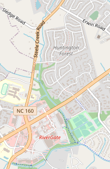
As I dug into this I found that Sarah owned property close to what is now the intersection of I-485 and NC-160 on both sides of the interstate and also large parts of property along NC-160 south of that intersection. She owns the Huntington Forest area but also land around the NC-160 and NC-49 intersection, including what is now the RiverGate shopping mall in its southeastern corner. It took several hours, going deed by deed to figure out which ones were clearly not contributors to Huntington Forest and which ones were possible ancestors.
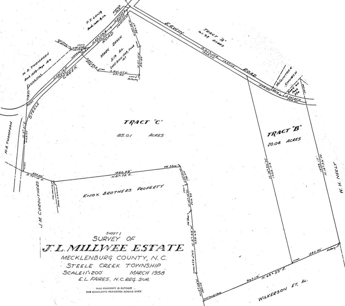
BEGINNING at a point in the center line of North Carolina Highway No. 49 (York Road), said point beginning N. 60-41-24 E. 456.00 feet from the intersection of the center line of N. C. Highway No. 49 and the center line of N. C. Highway No. 160 (Steele Creek Road) [...]
The modern intersection of NC-49 and NC-160 is slightly to the east of the historical intersection. Originally the two highways intersected as straight lines but an improvement to the intersection in the 1990s had NC-160 curve to the east before curving back to return to its former path. You can see the "hump" where NC-160 curves on the modern map above and also see the course of the original straight line path. On the Plat Plotter website I just marked the original intersection by eye.
The starting point for the metes and bounds is not at that intersection, though: it's at a very precise "N. 60-41-24 E. 456.00 feet" from it. What does that mean? That's how the surveyors encode the path around the property. "N. 60-41-24 E." is the bearing, the direction for the next segment in the boundary starting from your current location. It starts with N or S, meaning north or south, then the 60-41-24 is the degrees, minutes and seconds of the angle from north or south. The E or W at the end indicates if your bearing is turning towards the east (or clockwise from north) or turning towards the west (counterclockwise from north). To summarize, to find our property corner and the starting point for the metes and bounds you'd start in the center of the (former) intersection of NC-160/NC-49, you'd face north, turn 60 degrees clockwise, and march forward 456 feet.
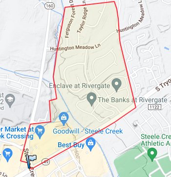
Once you have the starting corner selected on the map you have the enviable task of transcribing all the legs from the deed into Plat Plotter so it can trace the boundary. Tract B, not pictured, covers a large portion of the RiverGate shopping mall south of Tryon St. Tract A, pictured below, is our jackpot. It clearly covers the bottom 2/3rds of Huntington Forest, including the house that we purchased!
There is still more title research to be done, though. The Knox brothers sold in 1967. Where did they get the land? Once again, the deed is less than helpful - it does not reference any prior deeds. The trail has gone cold. To get the search started again I turned to genealogy research. Luckily, the 1950 Census was recently released to the public. It was written entirely in longhand but the government also made an attempt to OCR the text and index it. I found the Knox family in enumeration district 60-16, called Steel Creek. There are five people in their household: Julia (65), Jessie (55), Malcolm (56), Hugh (57) and Paul (54). They are all siblings and have never married. My interest is piqued: who are these five adult children, never married, all living together on the farm?
For additional censuses and biographical information I turned to familysearch.org, a remarkably comprehensive database run by the Mormon church. I had never used it before and was blown away by the depth of data and level of integration. The Mormons have been hard at work, pulling every public data set they can find, scanning it and OCRing it, and doing a great job of linking sources to people and building family trees. The Knox family is in good shape.
Their father, Dr. John Knox, married in 1880 in Steele Creek. He was a well-known physician in Steele Creek and had eight children. Three married and moved away from Steele Creek, the remaining five stayed on the family farm. Hugh, Malcom, and Paul - the three men who stayed to work the farm - served in World War I. Julia and Jessie were homemakers for their entire lives. After Hugh and Malcolm sold the family farm to the Gambrells they appear to have moved to a nursing home in Pineville and passed away in 1978 and 1979. I am astounded at the level of detail familysearch.org has on this family. They have the original, hand-written World War I draft cards for all the children scanned in and OCRd. They have the military record file (really just a single 3x5 card) for everyone. They have everyone's death certificates scanned in and linked into their profiles.
Looking back at the registry of deeds you can paint a picture of the history of the family. Dr. John Knox purchased a small lot for his home in 1881 (shortly after marriage and right around the birth of his eldest) just north of the modern intersection of NC-160 and NC-49. His homestead is featured on a map of Mecklenburg County from 1911 where NC-160 (Wright's Ferry Road), NC-49 (Yorkville Road), the Pleasant Hill Presbyterian Church, and Walker Branch are all visible. The names of neighbors featured here often show up on the metes and bounds of Knox land painting a picture of a small community where farms are held in families for decades and generations.
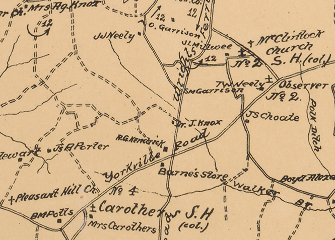
In 1885 Dr. John Knox purchased land on the eastern side of NC-160, including the land that becomes our property in Huntington Forest. You can see on the 1911 map that there are no houses on the east side of NC-160. It's prime, flat farming land and was reliably used for farming for decades until the whole area was developed. When Dr. Knox passes away in 1911 we see some deeds related to inheritance and dealings among the children but they keep referencing the original, hand-written deeds from the 1880s. This continues all the way up to deed 2703-277 in 1965 where the state pays the surviving brothers for the expansion of NC-160 and NC-49.
The Gambrell deed, made only a few years later, doesn't reference prior deeds by number or metes and bounds description. After almost 90 years the patchwork history of this land was getting a bit complex and could use some simplification but the surveys themselves also desperately needed to be redone. The original 1880s surveys were probably adequate for rural Mecklenburg County at the time but were quite inaccurate. Bearings on the metes and bounds were measured in whole degrees with no minutes and seconds, no doubt due to the technology available to those surveyors. The deeds referenced long gone roads, trees and other monuments such as a "stake on the branch with Sassafras pointers" from an 1885 deed. The more accurate Gambrell surveys translated into nice diagrams with PlatPlotter but the old surveys require substantial guesswork to figure out what they're trying to describe.
My best guess is that the southern half of Huntington Forest (the eventual Tract A in the Gambrell survey) was originally purchased by Dr. John Knox in 1885 in deed 44-10 from S. A. Carothers. The starting point is not clear from the description. I believe that when the surveyors refers to a "branch" they mean the Walker Branch creek and I also think they refer to the tiny creek behind the modern day Publix as a "drain". Even if the map location or the survey is inaccurate 44-10 seems the most likely candidate given its size, neighboring properties, and lack of other Knox tracts that could plausibly cover this amount of area.
S.A. Carothers didn't own the land for very long. He purchased the farm in 1881 from the estate of A.R. Erwin in deed 44-8. Things are getting fun now: the recording of the deed is in longhand and the scribe here has pretty good handwriting. As we get further on we'll find it harder to read handwriting and the quality of the scans gets worse. Note that the 44-8 deed is recorded along with the 1885 deeds. Modern land sales record the deed immediately but it is not a requirement. A valid sale of land can be done without recording the deed - the recording only helps establish the details of the transaction in case of a future dispute. If you lacked the money to record the deed or it was too inconvenient to get to the county seat for recording you might skip out on it for a while. In this case, after the death of Arthur Randolph Erwin, his children Margaret, Violet and Sarah sold the land to S.A. Carothers.
Arthur Erwin and his family resided in Steele Creek on that farm for decades, showing up in the 1850 and 1860 censuses. But now the deed trail goes cold - when did the Erwins get the land? There is at least one other Arthur Erwin in Steele Creek at the time which complicates the search. I see some likely deeds in the index but the scan quality doesn't let me read them. Unfortunately, my search comes to an end here. Perhaps I will have time to go in person some day to read a higher quality copy of the deed book.